Project:
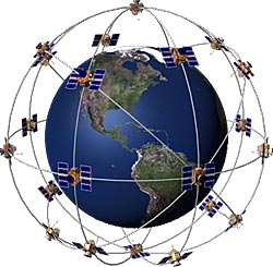
A. Explain to me, using a hand-drawn picture, how GPS works.
B. Use Google Maps/Google Earth and find the exact location of five landmarks in the West Delaware District. Create a series of vector representations that tell me how far each landmark is from the old front door of the school. List the starting GPS coordinate, the final GPS coordinate, the path length/degrees, and the two legs.
C. Check into these location, as well as the school using a GPS receiver or a smartphone software tool. If you choose to use the GPS, you will need to geocache the trip.
Common smartphone tools:
- Facebook checkin video (you would need to friend me)
- Foursquare (again, friend me)
- Mapmyride.com or the video explanation
Turn in your completed project by Tuesday at the end of class. Groups larger than 3 will not be accepted.

No comments:
Post a Comment